
This is one of those walks where I cross my fingers and hope the route will 'go'. Especially as we pop out onto the first high point and realise we've tracked a little bit too far north. Which is not surprising as we have no topo map to hand and bugger all pre-trip research that can help us navigate a route. Even the access road proved so anonymous it took a day to find it. This is becoming one of those walks that we keep re-thinking, on the fly.
We are trying to find Mt Plagyan - an ancient mountain tucked away in a rarely visited parcel of land at the southern extreme of Mt Kaputar National Park, in north-west NSW. It's one of those spots we have taken a punt on. We spotted it while camping at Camel's Hump in the main section of Mount Kaputar National Park - visible way off in the distance (read here, WAY OFF). But, close enough to entice us on this wild goose chase through the unchanging, sameness of acre after acre of cypress and box woodland. And that first high point, saves us. As we 'pop out' of the woodland onto the rocky hill, Mt Plagyan is visible and close. It also looks spectacular. The punt has already paid off. There is a sweeping wall of rock along its north-west flank. This towers over a deep gully. At the head of the gully is a collection of awesome, rounded, chunky rock pinnacles. Man, I hope our new route goes.


Before arriving, all we knew about Mt Plagyan and The Pinnacles was Caz's memory of it appearing in the pocket guide to climbing Kaputar, published by Rock magazine in 1993. Online searching for more information proved little help. All we found was a ridiculously vague map on the NPWS website outlining that horse riding is allowed on the surrounding trails. SixMaps proved inspiring but unhelpful with navigation 'in the field' where there would be no coverage. And we had no time to source the topographical map for the area. Anyway, Caz enjoys nothing more than a mapless off-track navigation challenge. So, off we went.
As the horse riding map indicated, we drove south from Narrabri to Maules Creek then east to Glencoe Road at the end of which we turned hard right and entered a narrow, wooded easement with two black soil wheel ruts to follow. There were two gates to go through and finally we were back in the National Park. However, within this section of the park, no vehicles are allowed. We parked the car just inside the gate at a 4-ways intersection and walked the rest of the way taking Pinnacles Creek Rd. My vague track notes in my journal may prove of little help to the next interested walker: I wrote: "after passing All Ites Fire Trail on our left, walked about 20 minutes, past the big boulder sitting on an old fuel drum, then after the second gully we headed up!"

Off track walking through open cypress forest is lovely and the climb proved gentle until we reached the fabulous rocky high point. It was a steep push to the top but, this gave us our first views towards The Pinnacles of Mt Plagyan.
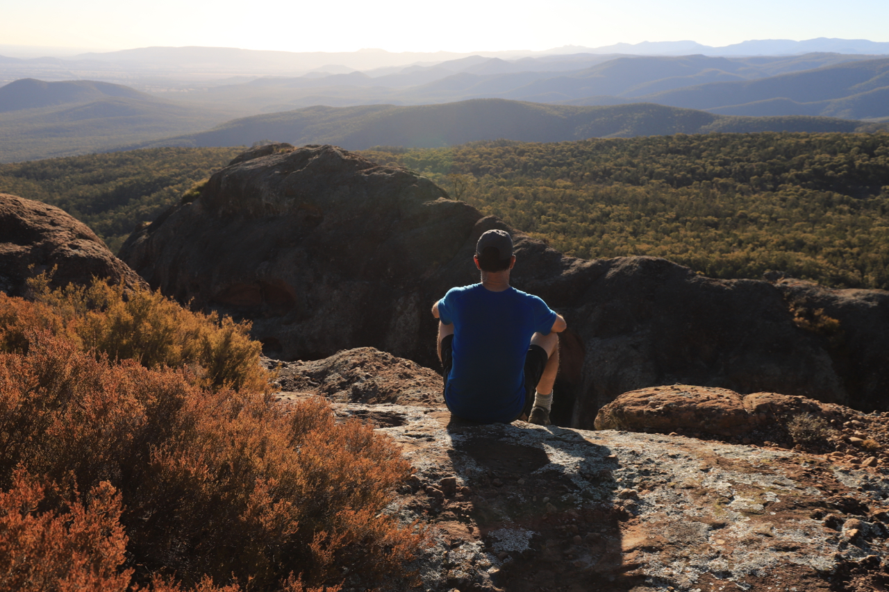
Standing atop the rocky hill is a chance to chose a rough route for the next section of the walk. Because we have come too far north, and are now on the wrong side of the cliff-lined gully beside Mt Plagyan, we decide to try and round the head of the gully to reach the Pinnacles. This is where we are not sure, if the route will go as it will take us into the heart of those rock spires with possiby no way up onto the mountain. But, if there is a nice campsite along the way, with open views like this, then we will simply pull up stumps early, camp high, and enjoy the view across to the mountain. There isn't. So we don't. On the fly again, we keep walking following an eastwards running ridge to our dubious route through the Pinnacles.
Standing atop the rocky hill is a chance to chose a rough route for the next section of the walk. Because we have come too far north, and are now on the wrong side of the cliff-lined gully beside Mt Plagyan, we decide to try and round the head of the gully to reach the Pinnacles. This is where we are not sure, if the route will go as it will take us into the heart of those rock spires with possiby no way up onto the mountain. But, if there is a nice campsite along the way, with open views like this, then we will simply pull up stumps early, camp high, and enjoy the view across to the mountain. There isn't. So we don't. On the fly again, we keep walking following an eastwards running ridge to our dubious route through the Pinnacles.


At the end of our ridge, and the head of the main gully, we cross a small saddle and find ourselves right at the base of those magnificent Pinnacles. It gets a bit scrappy with hop bush and cough bush, and there are a few tricky manoeuvres to find a path through, over, and around, each Pinnacle. Resting in one small gully, under the shade of an old fig tree, I spy evidence from some of those creative souls who carve their names into tree trunks - one reads Peter 16.6.76. There is Jim and Ryan, also here in 1976 and another name from 1984.
We leave then to their history and weave our way through small grottos of shade and secrets, tucked between each Pinnacle. Despite being quite hard at the end, hauling our big packs up rocky ledges and down steep gutters between pinnacles, the route is superb. We swing from fig trees in small pockets of rainforest and leap across crevices before finally reaching the top of Plagyan and its Pinnacles with views north across the whole Kaputar/Rusden Wilderness. Its a great sense of achievement, our route did work - it goes, we went.
We leave then to their history and weave our way through small grottos of shade and secrets, tucked between each Pinnacle. Despite being quite hard at the end, hauling our big packs up rocky ledges and down steep gutters between pinnacles, the route is superb. We swing from fig trees in small pockets of rainforest and leap across crevices before finally reaching the top of Plagyan and its Pinnacles with views north across the whole Kaputar/Rusden Wilderness. Its a great sense of achievement, our route did work - it goes, we went.

Up close, the rock of the Pinnacles appears to be a sort of granite and conglomerate. The big spires and cliffs contain lots of deep hollows, niches and small caves. They are streaked orange, grey, black,. Peregrine poo stains the high points.
That night, lying out in our bivy bags atop Mount Plagyan, the sky seems as textured as the rock with patches of darkness like deep hollows, the stars a conglomerate of lights, me lying in a niche of life, looking out.
That night, lying out in our bivy bags atop Mount Plagyan, the sky seems as textured as the rock with patches of darkness like deep hollows, the stars a conglomerate of lights, me lying in a niche of life, looking out.


At 3am though, we wake to some epic winds. By 5am, it is absolutely roaring; the bivy bags snapping and cracking in the high winds. It is a tricky, early, and rushed pack up. The sky fills with dust. The sun rises as a huge orange ball, casting no shadows.
To escape the roaring mountain, we head along its main east-west cliff line. The views back to the Pinnacles are amazing. But, it's a fast, harried walk in the powerful gusts. We drop down a steepish, short gap in the cliffs and, once in the forest, we ease back a notch. The walk back to the fire trail is filled with more fun and wonders - a dry waterfall, some steeper drops, the way one of the Pinnacles looks like an elephant, the amazing luck of coming out on the fire trail right on the bend, the kangaroos and wallaroos we walk with, a family of babblers, and a rest at the crossroad where the wind gusts strongly overhead while we sit on the sun-soaked bark of the forest floor thinking quietly: well that was a good route, out and back, wouldn't change either.
Mount Kaputar National Park is currently closed due to extensive recent bushfires (which have burnt out 18,478 hectares of the Park). However, the Plagyan section was spared and, according to the NPWS website, is not one of those areas affected by the closures. However, it is preferable to walk in winter due to the extreme heat in western NSW so maybe save this one for next year.
All images and words on this site are copyright of Craig Fardell and Christina Armstrong. It is illegal to sell, copy, or distribute images and text without permission. We thank you for your help in respecting the copyright of our work.
No comments:
Post a Comment