 |
| Never Never River |
Seeing Glennifer Falls for the first time was one of those 'wow' moments. I vividly recall being amazed at how this magnificent waterfall had been hidden in my backyard for so many of my bushwalking years without me having seen it.
Since my first visit, eight years ago, we have been to Glennifer Falls on multiple occasions and each trip has been different, but always challenging, and continually spectacular. The waterfall is tucked away at the end of a rugged and trackless valley, and the rock hop up the Never Never River to the base of the falls is long, strenuous and involves either an icy swim or a high traverse to get past a small gorge before the falls come into view.
 |
| The entree before the main - Glennifer Falls is visible in the background |
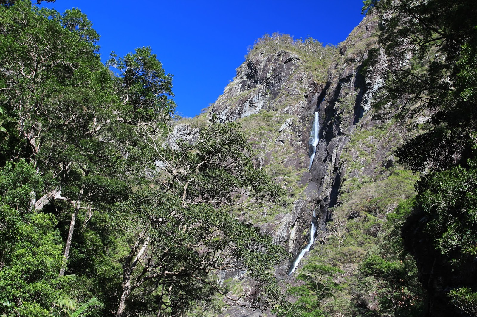
Glennifer Falls drops in two visible long falls – the second of these coursing down a narrow, vertical fissure in the face of the mountain. The total visible drop is easily more than 100m, but above this the river steps back in three earlier falls, one of these being an impressive 60m.
Located in Dorrigo National Park, access to Glennifer Falls is easiest from down in the valley, north of the wonderful old dairy-farming town, turned hippy retreat, of Bellingen. The idyllic, peaceful start to this walk, meandering along the gently forested river bank, belies the rugged, difficult terrain towards its end. Travelling upstream to the falls is a matter of crisscrossing the riverbed, finding easy rocks to hop across, and sometimes venturing onto the narrow rainforest bank either side as you skirt around huge brushbox trees, massive boulders and narrow cascades. Summer is definitely the best time to go. You can swim in the deep green pools and bask on the hot rocks to dry off, or stay under the shady, cool rainforest and watch butterflies drift from tree to tree.


The trickiest part of the walk is on reaching a small, sheer-sided gorge. Here the best option is to backtrack a few metres and follow a steep traverse on the right bank, which starts by climbing a rock gully and then walking up high around through the bush (a rope might be useful, although not essential, for those who are less experienced at this sort of scrambling). A footpad on the traverse is lightly visible and easy to follow once found. It brings you onto the rocks above the gorge and ahead are three large-ish and pretty waterfalls. These are not Glennifer Falls. Raise your eyes and look ahead to the end of the valley and the large spectacular drop of the true waterfall is visible.
The best viewing point for the massive scale of Glennifer Falls, is above these three small waterfalls after the gorge. All these falls can be climbed on the right bank, but only when conditions are dry and water levels low. The middle section can get slippery at times as you follow a small side channel often running with water. But, once up and past these, it is simply a matter of jumping across the water and climbing onto the first big boulders so that Glennifer Falls can reveal to you its 'wow' factor. The top and bottom drop of the falls are visible and the narrow, slotty course and the sheerness of the mountains is awe inspiring.

Up high, in the course of the waterfall, you can see hints of a horizon pool. According to Caz, floating at the edge of this pool gives a terrifying perspective across the valley below. He knows this because many, many years ago he and some friends, Dick Baker and Brian Cork, undertook the serious and challenging adventure of abseiling down Glennifer Falls, beginning with the three earlier falls that are set back before the main spectacular drop. They then swam across that horizon pool before tackling the first of the long falls then exiting onto a narrow rocky ridge and descending to the south of that last massive drop, rather than abseiling into the fissure and following the water flow.
A more recent attempt at Glennifer Falls can be seen on YouTube here. This little video is definitely worth taking the time to watch, just to get a sense of the height and wildness of Glennifer Falls which these guys measured as 350m from the top of the first drop to the very bottom. Although they did not manage to abseil the length of the falls, due to dangerously high water levels, the video does cut to some great footage of the walk upstream to the base of the falls.
A more recent attempt at Glennifer Falls can be seen on YouTube here. This little video is definitely worth taking the time to watch, just to get a sense of the height and wildness of Glennifer Falls which these guys measured as 350m from the top of the first drop to the very bottom. Although they did not manage to abseil the length of the falls, due to dangerously high water levels, the video does cut to some great footage of the walk upstream to the base of the falls.

It is easy to be distracted by the spectacular nature of Glennifer Falls and forget the surrounding beauty of the rainforest in the low valley of the Never Never River. After enjoying lunch at the boulder-strewn viewing spot, the return journey back down the river is a good chance to take in the rich green forest, the giant bird's nest ferns, the summer flowers of flame trees and shrubs, the gnarly old watergum roots wrapped around giant boulders, moss lined rocks beside the clear green water and gravel banks of rolled river stones as smooth as skin.


There is other information out there about this walk including some wonderful photos by Ian Smith at the Bushwalk Forum and on Virtual Tourist.
Even if you don't, or can't, make it all the way to the viewing spot to see Glennifer Falls, the walk up the Never Never River is a treat in itself. This is a remarkably pristine water catchment and even in times of flood the river rarely runs dirty. If summer storms stop you from walking upstream (summer is the time for floods in this part of the world) then bring the lilo. Low down on the river, from bridge to bridge, when water levels are high, this can be a great trip.

 |
| Glennifer Falls |
All images and words on this site are copyright of Craig Fardell and Christina Armstrong. It is illegal to sell, copy, or distribute images and text without permission. We thank you for your help in respecting the copyright of our work.
Nice story guys, I love your enthusiasm for nature. Sad to say I've only completed part of the 'scramble' up the Never Never in my 30 years in Bellingen but you've inspired me to revisit....not sure about your ref to Bello as a 'hippy retreat' tho!
ReplyDeleteHi Colin, great to hear from you. Glennifer Falls is definitely worth the effort. Has to be the most spectacular waterfall within the region and not that far from your place - as the crow flies! Hope things at the nursery are going well. Cheers, Caz. (P.S. It is still possible to see the odd tie dyed shirt and dreadlocks in town!).
DeleteGreat photos and story. We first walked to these falls in the 90s and just yesterday found our photo album hidden under a other stuff stored away, and immediately thought, wow let's go there again real soon. Found your blog today when looking for directions. We're a bit longer in the tooth but still wilderness walk. We sail and are down in Tassie for half the year working on resurrecting over grown tracks. Here's a snippet
ReplyDeletehttp://jackandjude.com/log/the-hunt/
best wishes Jack and Jude
Great blog which I've only just discovered. 2 questions I'd like to ask. Where did you start your walk from exactly. You say "The idyllic, peaceful start to this walk" but you don't say where. (Did you start at the end of Godings Road?) And secondly do you carry a hand help GPS and if so would you recommend one?
ReplyDeleteThanks
Hi Mark, and thank you for waiting patiently for us to reply to your questions! We have done several walks to Glennifer Falls and started them all at slightly different spots near or from the Promised Land Road (and even from above on the plateau). We never carry a hand held GPS and rely entirely on compass and map navigation for route finding. We recommend that everyone who ventures off track, or into remote bush, have this skill - you never know when a GPS battery, and/or remote area coverage, might fail! Thanks for visiting our little blog page and feel free to email us if you have any other questions.
DeleteHi, thanks for this great info. We are planning to do the waterfall and just wondered approx how long we should allow to get there and back? We are experienced walkers. Just can't find any details about the distance etc etc. cheers from Polly
ReplyDeleteHi Polly, and thanks for dropping by our blog page. It is a full day walk. A minimum of 6 hours walking time, add on to that any breaks and rests and lunch time. It is rock hopping and scrambling with no track. It requires a good level of fitness and experience. We would recommend you obtain the topographic map (Brooklana 1:25000) and from that you can work out distances. Have fun out there.
DeleteAwesome thanks very much for that info and we will get the Brooklana map. Happy hiking from Polly
ReplyDeleteHaven’t made it to the base of the falls as yet, but did make it to the top off the falls on a 3 day hike in Dorrigo National Park recently, awesome part of the world
ReplyDelete