 |
| Manning River 60r |
We spread the topographic map on the lounge room floor and spot a relative. We should go visit. It looks like a perfect trip for us. A renowned relative, seldom seen; found in deep, steep-sided wild country.
What relative?
Well, on all NSW 1:25,000 topographic maps many waterfalls remain unnamed and are marked simply with a blue line across the watercourse and beside that some digits followed by a lower case 'r'. The 'r' indicates a cliff or a drop 'relative' to the surrounding landscape. On the upper Manning River, in Barrington Tops National Park, there are several such relatives, the most visited being 8r & 23r, and further downstream, 60r. What that implies is an 8m, 23m and a 60m waterfall. Now that's a bunch of relatives worth visiting.
The 60r waterfall is sometimes called Manning Falls or Kangaroo Falls (as it drops just above the junction of the Manning River with Kangaroo Creek). There is a little bit of information out there on the interweb about this waterfall, a few pics, a few rough directions and through word of mouth and bushwalking friends we knew the most common access was by first driving Dilgry Circle, onto Thunderbolts Trail, onto Gummi Trail and right onto Sassafras Trail then walking off track along a ridge before dropping steeply down a scrubby loose slope to the top or the base of the falls.

 |
| Looking upstream into the canyon |
But, the topographic map is our starting point - Pigna Barney 1:25,000 - and on closer inspection we choose a different route. We have also been told about access from Alberts Top Road, where a short walk through a maze of old forestry trails brings the intrepid explorer to a steep open ridge with views back to the waterfall.
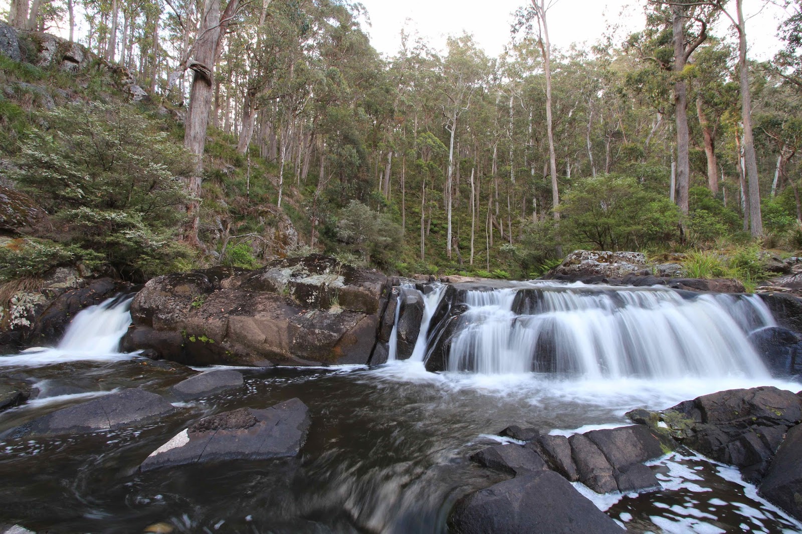
We set off early and the overgrown forest roads, crisscrossed with fallen timber, are indeed a maze but a good navigational challenge. There is a bit of to-ing and fro-ing and cutting back and across a slope until we are on the correct line towards the steep descent spur that will bring us to the Manning River below the falls. The final 280m drop in elevation to the river is really steep. It is a loose, open slope and from the top looks more like a cliff than a possible descent route. But, we begin picking our way down and, as always, it is not as vertical as it appears. It is still hard work but we get stunning views of the valley below and our first views upstream to 60r. It's a cracker of a waterfall. We sit on a small rock ledge for a rest and to take in the spectacular view. How we actually get to the base of the falls from this approach route, is unknown. But, we continue down the knee-knocking spur until we finally hit the river. The walk from the car to this point has taken about 4 hours.
We land at the river at a horseshoe bend and in one of those miracles of off-track walking it boasts a tiny flat area big enough for our small tent. There was a time when my biggest worry, walking in to unknown destinations, was whether we would find a campsite or not. I've since learnt there is always somewhere - rough or otherwise - and we do not need much space to make a home for one night.

Having 'chosen' our only campsite option we dump our big backpacks and begin exploring upstream. After 500m we arrive at a small canyon with sides 10m or more high and only 6m apart. A long cold, deep pool bars our way and it continues upstream for about 10m before turning ninety degrees to the right and disappearing. Around this bend we can hear a mysterious waterfall and can see its plumes of spray drifting out over the dark water. There is absolutely no doubt we have to see what is around that bend. Caz wants to take his camera but swimming looks like the only option. I have a closer look at the 'true left' wall and can see submersed rocks and ledges.
It is quite a sight, down there in that deep valley, between the canyon walls, two naked bushwalkers creeping gingerly around the edge of the freezing water on slippery rocks. But, we get there and it's a lovely little cascade, dropping 20m in a twisting dog-leg from the pool at the base of 60r.
After retracing our steps in the waist deep water, we dry off and return downstream to where a break in the cliffs gives us the opportunity to climb up the side of the river on horribly loose rocks and ledges and through scrappy vines and shrubs before traversing nervously across slope above the rim of the canyon and cascade and finally emerging at the base of the impressive 60r.
 |
| Where's the walker? |
It is tiring, tense scrambling but it is a spectacular spot. The waterfall itself is probably about a 50m drop but the cliffs either side continue to rise up to the 60m marked on the topo. We find a sling on a tree above the cascade from some friend's recent canyon trip. They tell us there is a terrific little canyon section above the falls as well.
As we relax on the edge of the enormous plunge pool at the base of the fall the sky above begins to darken and the first few afternoon raindrops begin. After a slow and tricky return to our backpacks we set up camp and put on an afternoon brew as steady rain begins to fall. The next morning, our plans to continue downstream and return via a different ridge are thwarted by the treacherously slippery rocks. We received more than 10mm of rain in the night.
We do explore a short way downstream (without our backpacks) and are stopped when we reach a 4m ledge of rocks that stretches across the entire river. It could be down-climbed on river right but we have no rope and the rocks are greasy. As we turn to leave, beams of sunlight finally break through the overcast sky and fill the rainforest with beautiful light. The sides of the valley tower above us, covered in thick rainforest. It is a good place to feel one's smallness in the world.


The steep walk out is a steady, hard grunt but once up, and back on the forest roads it is easy going. We retrace our way through the maze like Hansel and Gretel following breadcrumbs. Maybe if I had had breadcrumbs to look for I wouldn't have been wandering along so blithely unaware of the track ahead. At the very last second, as I step over a small fallen sapling, I am forced to pause with my foot mid-air before it comes down on a large brown snake sunning itself in the early summer heat. I hit reverse, slowly, back-track a few steps, as it springs to life and climbs the bank beside the trail.
 |
| Small cascade above 8r |
So with the most impressive relative visited, what about the little guys, 23r and 8r. We visited 23r previously, as a day walk, with access from Thunderbolts Trail down a 4WD road to a trashy little campsite on river right. It is a short-ish rock hop and scramble downstream to the top of the waterfall. To reach its base we took a scrappy route on river left with a steep drop at the end and plenty of bull ants nest's to avoid. It is a pretty waterfall with lots of ledges and drops and a strange progressive movement of the water from left to right. Harsh sunlight that day meant we unfortunately came home with few photos worth sharing.
 |
| The main drop of 8r on the Manning River |
The 8r is the easiest access of all the Manning River waterfalls and a terrific swimming spot on a hot day. It is accessed off Gummi Road. Immediately after the small picnic area, the road crosses the Manning River and there is a small pull-in/parking area on the left after the bridge. A clear footpad leads upstream to this pretty cascading waterfall.
So with Christmas approaching, of course it's time to visit some relatives. The ones in nature, the ones hidden on your local topographic map, or on ours.
 |
| Looking downstream from within the canyon |
All images and words on this site are copyright of Craig Fardell and Christina Armstrong. It is illegal to sell, copy, or distribute images and text without permission. We thank you for your help in respecting the copyright of our work.
It is a nice walk. My photo is one of the few that appear on Google images. We came in by Alberts Top Rd as well. Going in we managed to drop off the spur at the right point, for a not too difficult walk across to the falls. On the way out we went a bit higher and ended up on the grass slope above the cliffs. Was a little worrying. Must go back and look at the canyon. Have walked downstream from the 23m falls, but the next waterfall isn't very exciting.
ReplyDeleteHi Ken, thanks for the comments and the extra info!
Delete