The temperature each day is creeping higher and higher. It is hotter than November should be although the type of heat changes as our cycle touring adventure progresses – there is a dense humidity on the coast on day one through to the scorching heat of the bone dry tablelands. Each morning we start cycling earlier and earlier. We wake in the dark and wait for enough light to safely hit the road. Still, on day four and day seven we are caught out by hot winds, lack of water, tougher than expected hills and the many other, inevitable, ups and downs of cycle touring as we make our way from Coffs Harbour to Newcastle via the scenic route – Dorrigo Moutain, across to Ebor and Armidale, south to Walcha, then down to Gloucester and Dungog then back to the coast at Newcastle.

Day 1 – 46.6 km.
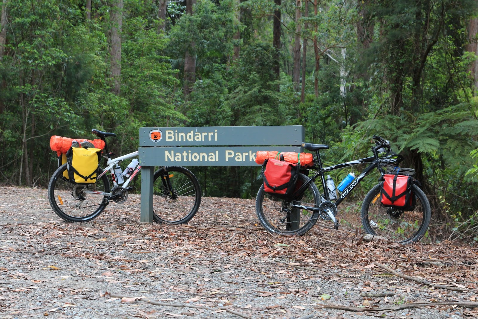
Leaving Coffs Harbour, November 18, 2014.
We take the old highway south from Coffs Harbour then head west on Glennifer Road parallel to the beautiful mountains that for so many years we have been exploring, walking in, canyoning down and calling home. Riding our mountain bikes along the winding dirt road brings a beautiful sense of freedom. It puts a smile on our faces, that feeling of setting off on an adventure. We climb through Bindarri National Park, passing tall blackbutts and flooded gums. Some pretty wooden farmhouses sit nestled in the green valleys and we enjoy their spectacular views to Mt Moonbil, the highest peak in the region. That night we find a camp by the Rosewood River, outside of Thora, surrounded by rainforest. As darkness falls, the flickering lights of tiny fireflies dance through the trees.


Day 2 – 14.4 km
Conquering the mountain.
The morning dawn chorus of birds is loud and complicated and exhilarating in its variety and volume. Fish are jumping in the deep pool by the bridge as we cycle off at 6:30am and immediately begin climbing toward the Dorrigo mountain road. Known as The Waterfall Way, the road is a spectacular drive with expansive views to the Bellinger valley and out to the coast. It climbs from near sea level to 762m. Thick rainforest rises steeply either side and the road bridges two waterfalls that crash down off the escarpment. It is world-class scenery and world heritage forest. It is also a massive physical effort to ride, particularly the early half of the mountain. At our first rest stop I feel puffed, slightly nauseous and questioning whether I can do the whole mountain. Is there a plan B? Not really. Luckily, by the first waterfall the gradient levels off and we steadily get higher and higher. We stop and rest a couple of times as the early humidity is sucking the moisture and energy straight out of us. Caz's helmet straps are dripping with sweat. It also runs down our arms and drips off our elbows. By the second waterfall the legs are burning but our next stop is the summit.


We celebrate our successful ascent with some holiday snaps under the 'Dorrigo Mountain 762m' sign but in an amazing change of weather, typical of Dorrigo Mountain, the sunshine disappears and within five minutes we are standing in a complete whiteout. As the cloud rolls in, visibility drops to less than 10m. We still have to get into the town of Dorrigo and end up riding along the roadside embankment to escape the traffic.
The reward for all that riding is hot chips at the local café and within 5 minutes of sitting down it starts pouring with rain and doesn’t stop until 2pm. With the mist and cloud lingering, it is easy to decide to call it a day. We're on holidays anyway, no need to rush, no deadlines, time to relax. The very nice Dorrigo Show Secretary lets us camp out the back of the showground beside the carnies who are setting up for the weekend show.
 |
| Dangar Falls just outside Dorrigo makes a great afternoon side-trip |
Day 3 – 46.64 km
Dorrigo to Ebor – a two fly day.
The ride to Ebor feels like riding three Dorrigo mini-mountains. At the end of one of the early climbs, we pass a man out checking his letterbox. He waves to us then looks up at the sun and assures us we will be in Ebor by noon. There are three particularly big climbs today but a rewarding 2km downhill to Coutts Water where we stop at 10:30am for 'lunch'. This is a new routine for us – bike tourers lunch at 10:30am every day! We may be saving costs on petrol but the food bill is huge. To supplement our diet we are having a "two fly" day – both of us sucking in two flies and swallowing them whole. Not sure of their nutritional value.


Hot tar bubbles up through the road and pops under our tyres but as predicted, by our man at his letterbox, we are in Ebor at 12:30pm for a true lunch at our favourite café – Fusspots. They make the best bacon & egg rolls around and have excellent coffee. Sitting in the sun, we get chatting to a man out the front. It turns out he is riding the Bicentennial National Trail by horseback but taking his time. He left Cairns 7 years earlier and has spent more than 12 months in Ebor waiting for better rains to provide feed for his horses as he travels. It is good to know the world is filled with adventurers.
 |
| Ebor Falls |
Day 4 – 75.5km
Ebor to Armidale – headwind hell.
The temperature has been increasing each day and checking the forecast reveals some hot, hot maximums looming. We cycle off at 6:15am without realizing just how intense things are going to get. There is a small climb out of Ebor, to the top of the Snowy Range with Cathedral Rock National Park off to our right. Then we enjoy a spectacular roll-down that lasts for more than 10km. We had thought today of just going as far as Wollomombi Gorge and camping there to sit out the heat but we are at the turnoff by 9am and so decide to push on to Armidale. First though, I stop into the nearby Wollomombi Primary School and bail up one of the teachers and ask to refill our water bottles. Turns out she is a keen cyclist herself and convinced one of the other teachers to ride to work via the back roads from Armidale, more than 40km. What a great commute! She warns us of the hills ahead but it is the increasingly gusty, powerful westerly wind that first catches our attention.

The last 20km into Armidale is hard. We later learn that Armidale recorded wind gusts up to 56km/hr and a temperature of 32 degrees – and we were riding head on into both. Well, Caz was. I was drafting behind him and watching in awe as he battled the headwind, forced to keep pedaling even on the steepest downhills. Strong gusts played havoc with our balance. We eyed off the stagnant looking pools of water in the Gara River and at Commissioners Water but climbing down the steep banks didn't seem worth the effort and so on we pushed. At the first park in town we stick our heads under the tap to cool down before riding in to visit our friends at Armidale Outdoors whose hospitality is always outstanding but this time is a real life saver - Jock offers us a bed for the night and the chance to shower, wash our clothes and relax in his cool, brick homestead built more than 120 years ago. Caz collapses on the floor as soon as we arrive and is worryingly quiet. Thankfully, he is successfully revived with a big bowl of pasta, sausages and a cold beer.
Day 5 – 70km
Armidale to Walcha – the hallucinations
Today we depart at 6am as the daytime temperature is predicted to get even higher. The cool morning air is delightful and a meat pie for breakfast at Uralla makes a perfect start to the day. Just outside Uralla we stop to take photos of a restored, old railway house at Barley Fields. I stop about 100m ahead of Caz and wait for him to get his camera out. A local farmer driving past pulls up to check Caz is okay and pointing in my direction says – "Have you two had a blue?". Caz reassures him everything is fine and the farmer nods ruefully, adding – "Well if it were me I would have had a blue."

The riding is steady and only lightly undulating and the wind is also on or tails so we make good time. It does mean we are also feeling the heat more. A headwind has the hidden benefit of cooling our sweat, but the tail wind makes it feel like we are sitting out in the baking sun and in a cruel hallucination the cicadas in the trees by the road make the same ticking sound as water sprinklers.

Day 6 – 2.2km
Walcha - sculpture tour
For a small town Walcha packs a lot of punch in terms of things to see and do. The temperatures are predicted to reach 36 degrees today (in fact in nearby Tamworth reaches 48 degrees!). We opt for a rest day and get up early to cycle around town looking at the 40 or more open air sculptures on public display. The town is also home to a significantly rare Aboriginal Dendroglyph tree at the museum. As early as 7:30am it is 32 degrees and after a quick ride out to the historic mansion of Langford we retreat to the lovely caravan park and sit like a couple of hobos beneath the shady trees, trying to stay cool.

Day 7 – 114.7km.
Walcha to Bretti Reserve - the lunacy
Never believe the car driving locals when they say "it's all downhill from here". This day nearly broke me and for the first time in my cycle touring life I got off the bike and had to push. Another hot day was forecast and we were cycling by 5:30am beneath a stunning sunrise that cast soft orange light across the old buildings and sculptures in Walcha. Out of town, along Thunderbolts Way to Nowendoc, the road was undulating – the sort where you work for one kilometre then roll for one kilometre. There was a steady climb up to the edge of the plateau followed by a fantastic 10km downhill into the Nowendoc Valley.
At the tiny store at Nowendoc we stopped for an icecream and our 'bike tourers' lunch at 10am. Already we had done nearly 75km and our plan was to stop near Nowendoc and sit out the day. The continuing unreliability of water supplies and the dreadful heat meant that we loaded up with 3.5 litres of water each as we cycled out of Nowendoc looking for a campsite but instead finding an unexpected and ridiculously steep uphill climb. Three quarters of the way up, I broke for the first time. Caz, in his generous nature, also got off his bike and together we walked up the last of the hill. So this is why they call them pushbikes.

It was hot and dry and the forest either side of the road was baking and unpleasant to camp in. After two more difficult steep climbs we finally stopped about 12:30pm and pushed the bikes off the road into the forest, with plans to camp and rest. We set up the tent, stood around half undressed trying to hide from the scorching heat and then packed everything up again. At least on the bikes we generated a breeze that cooled our sweat.
By the time we made it to the famous Carsons Lookout, at about 3pm, my own lunacy was matching the weather's. The day had been a constant progression of hills and hard climbs and I was ranting loudly as a form of motivating myself to keep going. I focused my maniacal ravings on the lovely lady from the Walcha information centre who had been the first to utter the ridiculous words – "oh its all down hill from here."

The views across the valley below were spectacular and bizarrely Australian – two bushfires burning in dense forest to the west and at the same time wild storm cells visible to the north and south with bolts of lightning and heavy showers of rain. With only about one litre of water remaining, we finally hit the famous downhill to the Gloucester Valley. It is a 12% descent, then 8% and then another 12%. We were sling-shotted off the bottom of the mountain into the valley where I was once more forced to use my 'push' bike technique to get up a steep hill before day's end. For one big descent, there seemed to have been a lot of up.
Hot and exhausted and completely spent we rolled into Bretti Nature Reserve on the Manning River at 5:30pm where caravans and campers lined the grassy river bank enjoying their lazy evening drinks in comfortable camp chairs. I felt tired and demoralised when a lady walked up to us from a distant caravan and handed us two cold ginger beers straight from her freezer. I could have kissed and hugged her. I don't even really like ginger beer but nothing had ever tasted so good. She even took our water bottles and filled them up with cool water from her caravan tank and then left us in peace to quietly collapse on the grass.
Day 8 – 47.6km
The cruisey side to touring
The road through the valley is different to the tablelands – here we work for 500m then roll for 500m then work again for 500m then roll again for 500m. Up and down, up and down. It is pretty countryside with patches of nice rainforest, bellbirds pinging in the trees and king parrots foraging in the roadside grass. At Barrington Store we stop for a bacon & egg burger and a few kilometres up the road we stop again at Barrington Outdoor Adventure Centre to visit our friends Brian and Naomi and chat and drink proper coffee. This is the relaxed, cruisey side of cycle touring. We eventually force ourselves onto the road again and cycle a few more kilometres into Gloucester to restock at the supermarket and treat ourselves again with chocolate and fresh fruit. Then we cycle just a short distance out to a rest area at Stratford, where we spend the afternoon lying about before sleeping under the stars on a patch of grass next to the cemetery. Quiet neighbours, and we sleep like the dead.

Day 9 – 77km
Via the 'Gog
The heat is still an issue and now the roads are also busier so we leave Stratford at 5:45am to try and avoid both. We arrive at the small settlement of Stroud Road and no-one is around except the local storekeeper. We chat briefly. He asks about our trip and comments on how we must have enjoyed the section from Nowendoc because "it is all downhill from there". It's a running joke, now the pain of that day has worn off.
From Stroud Road we cut across a back road towards Dungog. This is perhaps the prettiest part of the ride yet – a winding road, beautiful spotted gums shedding their bark and the sweet smell of something flowering in the undergrowth. Galahs are screeching in the trees. There are a few small short climbs but we are in Dungog early enough for another meat pie breakfast – food of champions. From Dungog we head across to Clarence Town and pass through some roadworks. The lollypop lady shouts in an excited voice as we approach: "Woohoo, you guys are the slowest thing I've had all day."
Day 10 – 70.1km
It's all downhill from here
During the night a cracking storm whips through Clarence Town and behind it comes the cool change we have been begging for. It unfortunately also means a return to strong headwinds as we are travelling south straight into the rainy, grey morning. Caz is out the front again, dragging us along an open flat road towards Raymond Terrace, cheerily babbling about thriving on hardship and headwinds. At Heatherbrae the changing weather really rolls in and only a few hundred metres along the Pacific Highway towards Hexham rain begins bucketing down. Visibility is extremely poor. Semitrailers and a constant stream of highway traffic cover us in spray. Water is pooling deeply on the wide shoulder of bitumen. We make a tactical retreat into the Botanic Garden and shelter for 15 minutes until the rain eases again.
 |
| Another storm front approaches - Redhead Beach, Newcastle |
In Newcastle, we wind through back streets and along cycle paths to join the wonderful Fernleigh Cycleway, which follows an old railway route from the suburbs of Adamstown way down to Belmont on Lake Macquarie. It is extremely pretty riding and passes through Glenrock Nature Reserve and close to the coast near Redhead. We stop first at the Fernleigh Café at Adamstown for a bit of posh lunch and suddenly feel self-conscious about how much we smell – our last wash was a three days earlier and only a swim in the river. We sit outside on the footpath and downwind, considerate folk we are.
The final ride back to our finishing point involves one more steep climb but, we have wound around the suburbs to ensure we take the least difficult approach. With only 100m until the finish line Caz finally makes the comment, correctly this time, that - it's all downhill from here.
 |
| Lake Macquarie |
All images and words on this site are copyright of Craig Fardell and Christina Armstrong. It is illegal to sell, copy, or distribute images and text without permission. We thank you for your help in respecting the copyright of our work.
Great write up guys (and photography as well), loved it.
ReplyDeleteHey Phil, we were hoping you'd like this one! It's always great to use the bikes as our main mode of transport.
DeleteBeautiful photos and writing as usual. I struggle with 15 minutes ride to work. So many muscles that don't get used enough.
ReplyDeleteAlways ride from north to south then, looking at the map, it's always downhill. Keep eating the flys, they'll give you wings!
ReplyDelete