As we weave our way through tall open forest the Guy Fawkes River valley is visible to our right; its huge, yawning expanse contains thin pockets of morning mist but what I'm looking for down there are the wide riverside flats. They have me dreaming of a lazy afternoon sitting on a clear grassy bank, sipping a warm cup of tea, soaking up sunshine. But, we have only just left the car park and the river is a long way away. As usual, I'm getting ahead of myself.


For this walk we are planning to complete a well-know loop in Guy Fawkes River National Park, taking us from Chaelundi Campground, along the valley rim to Jordan's Trail, then down, down, down to the river itself, back along its banks for 10km past Combala Hut, across the big paddock, and then returning to our starting point via Lucifer's Thumb and Chaelundi Bluff.
Parking the car at Chaelundi Camp Area we take the Escarpment Track south along the edge of the range. We stop early to take pictures of flowering paper daisies then catch the movement of a pair of spotted pardalotes. They are gathering stringy bark for a nest and disappearing with it into the grass near an old stump. It is too good an opportunity to pass up and so I wait patiently behind a tree as Caz positions himself closer and closer. He gets some great shots and it seems a lucky way to start this trip.


Hiking along the banks of the Guy Fawkes River is straightforward with well formed trails to follow as a result of the population of wild horses that live in the valley. The Guy Fawkes horses are the descendants of stock bred by local graziers and sold to the Australian Lighthorse Brigade for WWI and WWII cavalry mounts. However, after the valley was declared National Park in 1972, and graziers left the area, wild horse numbers grew and grew until in October 2000 the National Parks and Wildlife Service undertook a controversial aerial cull, shooting more than 600 horses and in the process gaining worldwide, and unfavourable, publicity. As a result, a Heritage Horse Study was undertaken. The Guy Fawkes horses were found to be direct descendants of Australia's wartime cavalry stock known as Walers and consequently became the only group of Australian wild horses given official heritage value. The horses are now removed from the park in a more humane manner and are on-sold and managed as a breed by the Guy Fawkes Wild Horse Management Association Inc.


This park is certainly a twitchers paradise: we pass flocks of birds - 10 crimson rosellas, 20 silvereyes, 30 firetails, a wedgetail eagle and a white-breasted sea eagle sharing the same thermal of air, a rufous whistler, white-naped honeyeaters, yellow-faced honey eaters.


That night, dinner is finished and we are watching for shooting stars when there is a definite sense of movement somewhere down by the river, soft shuffling sounds and the distinctive click of hooves on rock and a swish of water. The shadowy form of two horses, one beautiful palomino glowing in the soft moonlight, pass along the river bank and then melt away amongst the river oaks.
In the morning we cross the river three times and walk onto the big paddock where Combalo Hut once stood. There is no evidence of the hut, just a few small, out of place looking trees in a clump. As we approach our next crossing six brumbies emerge from the river bank; ears pricked, heads high. The horses are surprised to see us but also inquisitive. They canter off up the slope before wheeling around in a large arc and returning to just fifty or so metres away. They look healthy and tough, small but strong. As Caz pushes the horses comfort boundaries for a closer photo, the lead mare takes off into the surrounding forest and the small herd follows. It is our cue to keep moving as well. We have a dozen more river crossings ahead before the next idyllic camp.


Mid-afternoon we pass the marked track that leads back up to Chaelundi Camp Area. But we're in no hurry to climb out of here. The riverside camping is hard to beat and Caz chooses us a campsite above a deep pool. It's been another hot day and after our swim we settle back for a cuppa. The afternoon passes quietly, peacefully. We wander around camp; using the brumby trails makes walking easy. Standing up on the open paddock above camp, I can see the slopes of the valley all around and feel the smallness of myself against the landscape and against the length of this river as it flows on further north.
In the morning we wake to see mist rising off the cold water and there is a light frost on the grassy flat. I watch Caz from the comfort of the tent as he wades out mid-river, shoes off, ankle deep in freezing water, hands fumbling with the cold aluminium of his tripod, all for the prefect shot.

The sun is not quite over the ridgetops when we set off to return to the car. We are not following the National Parks track but heading straight up onto Lucifers Thumb, hopefully by clambering over Chaelundi Bluff. We take the spur at the northern end of our bend. Initially there is a clear footpad and a National Parks sign posted a short way along aims to redirect us across to the main track that is on the neighbouring spur. We continue on, straight ahead, and the foot pad soon becomes fainter and fainter as we push through a thick patch of dogwood. Gaining height the terrain becomes more open, rockier and hotter, as the morning sun beats down. Sweating and puffing we hoist ourselves onto a rocky outcrop only to a surprise a brush tailed rock wallaby. It scoots off and we only catch a view of its disappearing rump. It takes about an hour to climb to the top of the first spur and then we drop into a grassy saddle before heading straight up again, keeping north of a dry gully. From here, it is a very steep up, but there are great views. We pause on one of the many rocky slabs and watch yellowtail cockatoos lift out of the forest, squawking and carrying on, before drifting away over the valley.
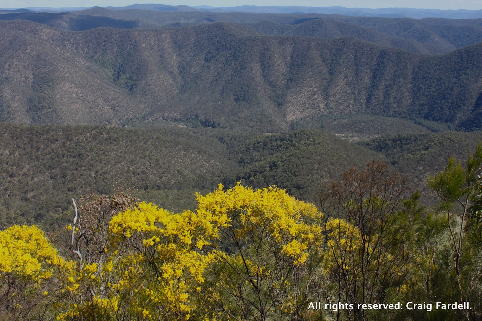

As this last spur tops out it becomes narrow and rocky and leads to the base of Chaelundi Bluff. Here Caz scouts around the base of the cliff for a route up. We sidle south of a large grass tree before hauling ourselves up a rocky chimney and then we are standing on top of Lucifers Thumb. The lookout point is spectacular, with uninterrupted views of the Guy Fawkes River valley as it stretches north and south. The wattle all around us is in brilliant bloom and we sit for a while taking in the view and recovering from the steep climb.
The track from Lucifers Thumb back to Chaelundi Camp Area is just 1.5 km. As we reach the car my sweat is drying and my legs are starting to seize up from the efforts of the down two days earlier and the even harder up of the morning. Still, the campsites were worth it, those pretty places no longer in my imagination or a dream, but in my memory.

Some more experiences in Guy Fawkes River National Park:
http://bushwalk.com/forum/viewtopic.php?f=36&t=10994
Sounds like a nice 'playground' Christina. Nice photos and the words made me feel like I was there in person!
ReplyDeleteThanks for the comment! Some of those horse-made trails might also be a possibility for mountain biking...food for thought!
DeleteKeep up the good work on your blog, I'm really enjoy the BNT stories around Main Range.
Great post, terrific blog. Love to know where you came up onto Lucifer's. We didn't know there was a way up there for sure, wish we had known:)
ReplyDeleteHi Julie, glad you liked the blog. There's no defined trail that we followed and the last bit onto Lucifers Thumb lookout was a bit of a rough scramble up a loose, rocky gap. Caz has an eye for these things and always seems to find a way through!!
DeleteChrissy :)